
Herb’s Blog, Herbdate 22755 – 980
Here’s the haps:
Sorry, this didn’t come out yesterday but time got away from me before I knew it. I’ve visited a few blogs but not everybody’s yet. Catching up as I can. Thanks for your patience.
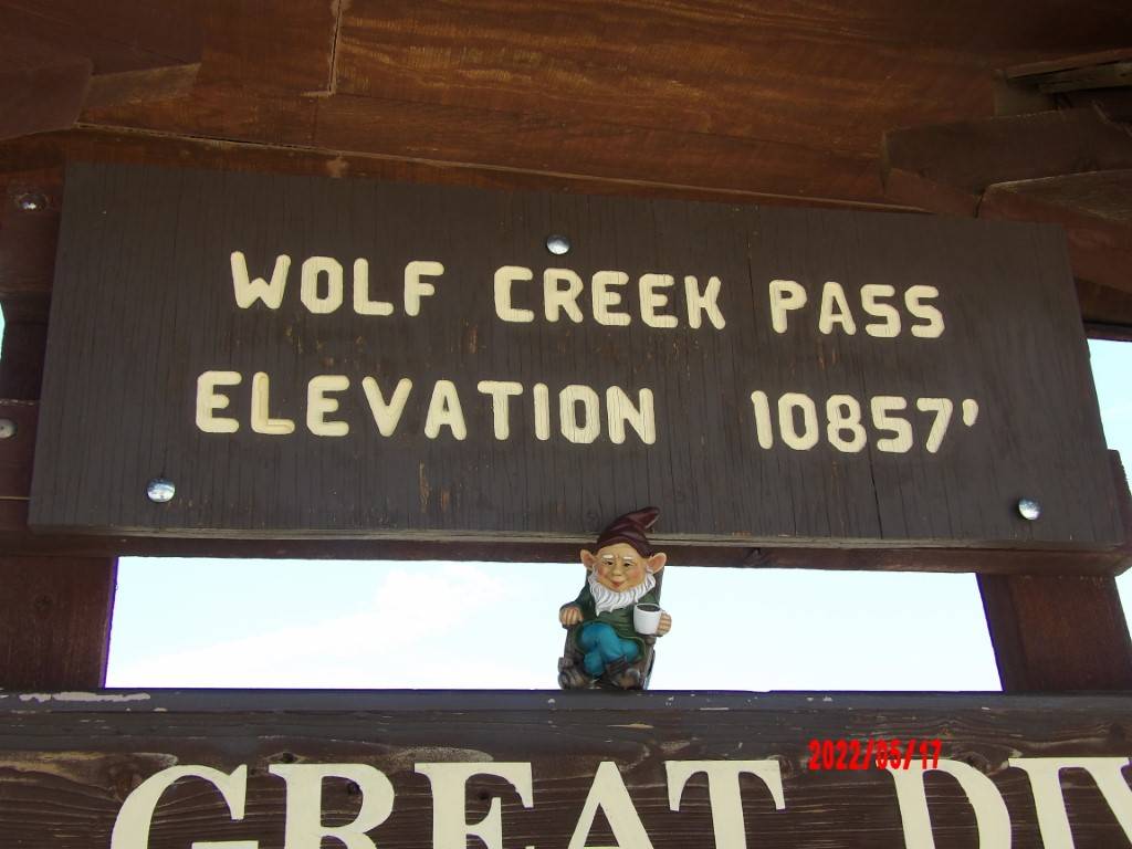
This part of the drive is a trip that I have wanted to take for many years. It was mildly anticlimactic because the road and the pass have been modernized quite a bit since 1975 when C.W. McCall recorded the song that captured my imagination back then. I have read about how, even with the many improvements, it is very difficult for semi-trucks driving either way.
It has a couple of cuss words in it which are pretty tame by today’s standards. C.W. McCall, whose real name was Bill Fries was a mayor of a small Colorado town. I had always heard it was Pagosa Springs but have since been told it was the town of Ouray. I had this album and a couple others by him for a long time.
I think the fact that I have been driving in the mountains for some time now and do know that if a sign says to take a turn at 15 mph it’s wise to slow down to at least that. If it says, “Icy Conditions May Exist” they very likely might, even in July. And I wasn’t driving a truck I was driving a rented 2021 Toyota Camry (which served us well) but I do agree with Earl about one thing, “My, ain’t this pretty up here?” The song is more of an artistic impression than a true description although that may have come with the improvements over the years. I don’t know how long those “Runaway Truck” exits have been around but I do know they have saved lives.
“So, why don’t you have more pictures, Herb?”

Well…Honestly, I don’t know what happened. I had transferred hundreds of files to the Onedrive cloud but this folder got messed up. A lot of the pictures just showed up as a blank white square. We had a few pictures of the inside of the lens cap, but those were black. Thankfully, they didn’t all get wrecked. I wonder if I corrupted the files by trying to copy the original into another folder to work on them before they were completely uploaded? Just this one folder, though. Maybe I will have to go back to drive it again and try to get more pictures.
We left Salida and drove down to South Fork and gassed up. I haven’t included any maps in any of these posts, I figure everybody knows how to work some map program or other if it interests them. Not sure if that’s the right thing to do or not but it’s what I’m going with.


The summit was beautiful. There is a bronze marker showing where the exact Continental Divide is and there is one national forest, Rio Grande National Forest, on one side and another, San Juan National Forest on the other. The Continental Divide is that part of the mountains where the rivers and streams on the west side flow down toward the Pacific while the ones on the east flow towards the Atlantic. We had a picture of Gnoel sitting on it but it’s gone. The picture we do have is from a spot directly above it.


Heading down there are areas without guard rails and there are hairpin curves and switchback and 180s but the only thing to remember is to go slow. Waaayyy slow sometimes.


Serendipity!
Serendipity is defined as:
the occurrence and development of events by chance in a happy or beneficial way.
As we neared the bottom of the drive we saw a parking lot with some cars pulled off on the other side of the and we asked ourselves what all those people could be looking at. I hung a U-ie and saw an intriguing sign that said “Treasure Falls.” I had never heard of it, nobody had ever mentioned it when we talked about our upcoming trip and we would have missed this if we hadn’t seen all the cars.


Only those pictures remain but for some reason, the two videos we shot with the same camera survived.
At the end of the road, there is a building that looks like it might have been a feed store in times past but now has several shops. The Ice Cream Shoppe, where I was hoping to get a real malt, was closed. We purchased some souvenirs and carried on down to Durango.
Next post: Durango to Four Corners Monument.

Comments
18 responses to “Road Trippin’ – Day 2 – Wolf Creek Pass Way Up On The Great Divide”
Keep on truckin’! 😊
Yee-haw!
I’ve been through this area several times and have deeply enjoyed the scenery and “feel” of it. Each visit felt unique and I saw new things each time.
The mountains really are like that, I think, too.
Glad your travels went well Herb. Hope your pix work out for you. Allan
Thanks. It was a weird thing and hopefully just a fluke.
We haven’t been on Wolf Creek Pass. I have driven Red Mountain Pass and Monarch Pass. This New Englander gets very scared driving these passes. I prefer to have my husband drive and I sleep until it is done. We got married on the Durango/ Silverton train. Thanks for sharing this. My husband can’t want to ski Wolf creek.
Thanks for visiting my blog! That is a cool wedding story, for sure. My wife doesn’t like the mountain driving either.
👋 Hi, Herb! We camped at a site in Eastern Utah -Moon Lake, maybe? – enjoy your trip!
I love camping. Hope you had fun.
Thanks for sharing parts of your trip Herb 😁
Yes ma’am, you’re very welcome. Thanks for stopping by.
I love traveling vicariously through my favorite bloggers!
I hope my future pics do you a service.
I am sure that I will not be disappointed!
I’m glad y’all found that place. Sounds intriguing
It was really cool. Never heard of it before, either.
I love the scenery of mountain driving. That’s a bummer about the pictures.